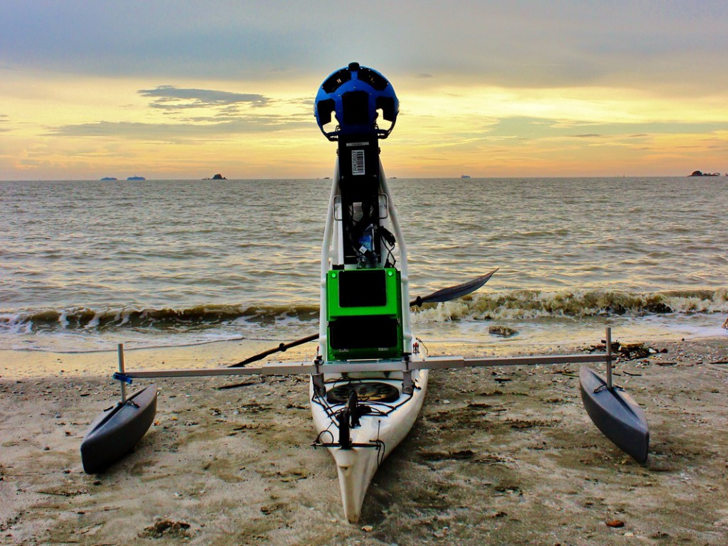
The Malaysian Nature Society (MNS) recently launched a solo kayak expedition covering more than 2,000km of the Peninsular Malaysia coastline named Paddle for Nature. Google supported this project in providing its Street View Trekker camera system to document all the footage of the expedition, allowing Google Maps user to view the coastline of Malaysia and maybe even some difficult to reach areas.
Hari Raju, 44, whom is a member of MNS will kick start the expedition on September 9, 2014 and will be departing from Pengkalan Kubor, Kelantan. The journey covers paddling along the coast, and around the islands of Perhentian, Tioman and Penang then all the way to Kuala Perlis and finishing in Langkawi. The expedition is estimated to take up 75 days with 40 stops along the route.

See more with Google’s Street View Trekker
The aim of this journey is to record and document the current state of the Peninsular Malaysia coastline with the Google’s Street View Trekker fitted into the kayak. This is the first time Google’s Street View Trekker is in such transportation mode. With the support of Google’s Street View Trekker, geotagged photographs will be shot for baseline documentation of the current land use along Peninsular Malaysia’s coast.
Faedzul Rahman, MNS Marine Conservation Manager, said that MNS is grateful for the support from Google in the use of its Street View Trekker camera system. This allows more comprehensive coverage of the coastline and ecologically important sites that Hari will be heading. These includes turtle sanctuaries, mangrove forests, seagrass beds, Marine Parks and nature reserves.

MNS’s effort to bring awareness
MNS wishes to create awareness on the importance of the country’s ocean heritage as well as to the local nature heroes supplementary to raising funds for future marine conservation projects.
“It’s easy to see jungles being cleared and terrestrial degradation, but it is more difficult to show people that corals reefs are dying, turtles are no longer laying eggs on our shores, and mangrove forests are being destroyed all around our country,” said Faedzul.
“Furthermore, there is lack of awareness about the impact this destruction has on our economy and ecology, the livelihood of coastal communities and the variety of wildlife whose habitats are linked to these coastal areas,” he adds.
He informs that marine conservation faces a special set of challenges due to this absence of awareness of the importance of coastal areas and the threats they face.

Hopeful Outcome
Through the expedition, MNS will compile the images and data of the marine and estuarine areas. This information will be useful to government agencies, environmental organizations and interested parties in the effort to protect Malaysia’s oceanic legacy.
There will be a MNS ground team following Hari in the expedition. In the planned outreach programme, the team will be exchanging thoughts and ideas with local nature heroes on their conservation efforts. In addition, MNS will be planning some events and activities for public involvement. The main sites for these events are Teluk Cempedak, Kuantan; Danga Bay, Johor Baru; Port Dickson; Lumut, Perak; and the end point, Langkawi.
Also, the public is encourage to pitch in to MNS’s “Donate a Kilometre” campaign in their efforts to save Malaysia’s marine ecosystem.
With this awesome effort, MNS is killing three birds with a stone – putting Malaysia into the big picture, working with Google to stock more archives into its Google Maps, and ultimately conserving the marine ecosystem.


