Instead of using multiple apps to find out the best route to get from your home to Eng Neo Avenue, and then pulling up the Google Chrome app on your phone to search for the nearest petrol station and then the nearest hawker centre, wouldn’t it be so much convenient if all of these information can be consolidated into one app?
Here’s another situation: what if you were tasked to find an Eldercare centre for your elderly grandmother, who has problems walking, because recently it has become increasingly difficult for your parents to care for her since they work shifts till late.
You’d like to find one where it is close to home or to your workplace, or maybe your parents’ workplaces.
As opposed to Googling for the list of elderly care centres and then searching for the addresses one by one on Google Maps, what if one app can provide reliable information on all government services?
Also, if you notice, the fastest walking route on Google Maps is actually a detour using the main roads instead of the smaller walkways and corridors through the neighbourhood.
While it is always good to follow what you can easily see, the real pedestrian hacks sometimes come from walking under our familiar HDB void decks – could be faster, and they shelter you from the weather.
This OneMap Is All You Need
…to rule Singapore.
Theoretically.
I found out about this neat new app, called OneMap, developed by the Singapore Land Authority (SLA) which had just been released in the middle of July.
Its Apple Store description says it “is the authoritative national map of Singapore with the most detailed and timely updated information” that also includes “useful day-to-day information and services contributed by government agencies.”
Other sources have described the mobile app as an “integrated map system” that uses “location-based data to solve problems.” Official SLA press release states that the app was “built by SLA’s geospatial engineers based on open source technology as part of geospatial capacity building.”

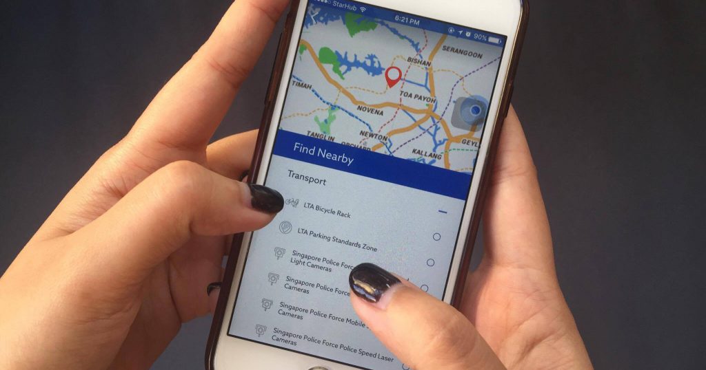
The OneMap app lets users search, navigate, locate nearby facilities and information, and choose map styles to the user’s preference.
It is actually a mobile extension of the newly updated OneMap.sg desktop version which was launched in 2010.
It can help users find the most sheltered or shortest routes to walk via the labyrinthine corridors of our HDB void decks, locate the exits and entrances of car parks and other buildings, and even view live traffic conditions.
All very useful features for both pedestrians and motorists.

Another cool feature that may not be especially useful to regular citizens, but perhaps useful for real estate agents and property developers would be the land ownership and land lot information found in the LandQuery tab.
Parents with school-going children can now easily look for places to park or places for a quick date while waiting for their children to finish their co-curricular activities in school with OneMap.
While the SchoolQuery tab on the app is not ready yet, all they need to do is to consult it to look for buildings near their kid’s school – and no more parking attendant worries.

Tap on the Search bar and you can easily find nearby amenities that conveniently lists down the nearest OCBC ATMs in the vicinity – extremely useful for people, who like me, only withdraws a limited amount of cash a day and then realising that it may not be enough for the mookata dinner.

This function is also great for searching nearby Gyms@SG, SAFRA Centres, and even Park Connector Networks (PCN) Access Points in the app. Leading a healthy lifestyle can now even start from the moment you step out of the office.
A Collaborative Effort To Give Back To Society

The content is put together with contributions from different agencies with the platform built with open source technology.
SLA launched a three-month campaign called “OneMap Ideaworks!” on 20 July, concluding on 12 October 2017.
Nanyang Polytechnic (NYP) students from the information technology, and business intelligence and analytics courses are participating in this project, already beginning development on a mobile application.
NYP’s software and innovation deputy director Melvyn Suan said the students are also developing geospatial information systems, using this “as an opportunity to hone their skills… that can solve everyday issues.”
Besides NYP, NUS Enterprise and SMU Living Analytics Research Centre (LARC) have also committed to the campaign, rallying its students, data scientists, and technologists for the cause.
Ng Siau Yong, SLA’s Geospatial and Data Director, raised an example of an agency that focuses on making commuting simpler for disabled people. He said the agency looks for wheelchair-friendly places and consolidates information on the best routes for people with physical disabilities to take, and makes these content easily accessible.
Two sources have reported that the Kwong Wai Shiu Hospital has taken the initiative to challenge app developers to answer transportation woes for wheelchair users. The Singapore National Stroke Association is also one such community partner issuing its challenge. Other community partners include Causes For Animals, Singapore Children’s Society, and more.
Mr Ng expressed hopefulness at the growth of the project to “strengthen the collaboration among different communities through the use of geospatial information science and technology.”
To participate in the OneMap Ideaworks! campaign or find out more about it, visit its website here. Download the OneMap SG app from the app store here or the Google Play store here.


